Tuesday, January 23, 2007

8/23 - A quick look at the Arches National Park

I fled away from the Canyonlands National Park around 3 P.M. to avoid a heatstroke. It was a beautiful sunny day and nothing provided the slightest shades in the park. Whity answered my needs with an air-conditioned cabin and I drove under the relatively comfortable temperature to Moab, Utah.

Moab was the biggest town I had seen in the past five days. It provided plenty choices of hotels/motels. After comparing the prices, again I settled with the Motel 6. I drove around the town for a change of scene after traveling in the back country of the nation for almost one week. When I came across this intersection, I realized it was the first red signal I saw for the whole week. I took a picture to mark my reentry to the modern life.

I drove around on the streets of Moab and finally decided to have a sneak peak of the Arches National Park before the sunset. The park is so close to the town that makes Moab a perfect location for its visitors. The entrance of the park sits quietly at a branch off the US-191 highway. It is so modest that it becomes a bit of surprise when people reveal all the beautiful scenery lies behind it.

There is an uphill climb after passing the park entrance and the newly built visitor center at the crossroad. As I climbed upward, I left behind the common world and got ready to enter the naturally made wonderland. The mother nature not only creates the magnificent Arches national park, but also prepares the stage so well that it is hard to believe everything is natural.

Driving up-hill anxiously to know what's hidden on the other side of the cliff...

Half-way up, looking down at the park entrance gate and the visitor center at the foot of the hill. US-191 highway on the left.
Finally reached the top of the plateau. It was time to explore.

Once I reached the top of the plateau, the first thing to greet me was the "park avenue", a wide-open valley with high rising cliffs on both side. It should be a very nice walk through the valley, but I had more to do for the very limited time. I held back my urge for another walk and drove pass the park avenue.

The Park Avenue.

Three giant stones resembling the shape of sages (It has a name I couldn't remember) at the Park Avenue.

I followed the road in the park, passing by the Balanced Rock and arrived at the windows section. This place got the name due to the many openings on the stone cliff around the area. I followed a ranger's suggestion to come here first. He told me this would be a nice place if I want to take some pictures of the stars, something I wanted to do for days but couldn't because I woke up early these days and got too tired to stay in the parks until late. I got maybe one hour before dark, so I decided to walk around the place first.

The first thing I saw here is a big opening in the middle of a cliff, just like someone has punched through a thin layer of styrofoam board. I know it is 100% natural, but that is really hard to believe. The opening is huge, so the term "arch" is really the best to describe it. When I came close to the arch, I saw a handful of other tourists there, so I took another picture, using them as a scale to mark how large the arch is.

This arch looks like someone has punched through the cliff.

With the tourists in front of the arch, you really get an idea how big it is.

I further walked around the area and checked out the other "windows". They vary widely in sizes and shapes, and the diversity makes the whole section very interesting to walk through. Obviously, some arches are older than the other. When I walked around, I felt like walking through a special exhibition in an art gallery. All the pieces displayed are unique yet tightly coupled to a unified theme. With every turn I made, there were more to gaze at with amazement, and more pictures to take... I ended up shooting most of the openings I could discover in the section.

These are the future windows in work.

A large window next to a small one.

Windows at the second floor....

There are so many of them, but each is unique.

Finally I came back to sit underneath the first arch I saw, waiting for the nightfall. All the tourists were gone, and I could hear nothing but the breeze blowing across the land. I sit there quietly and tried not to think much other than just feeling myself mystically blend into the nature surrounding me. I stared at the wilderness underneath the hill as the darkness gradually took over. It was a slow but persistent process. I just sit silently there, trying to feel every second of it. This was some exercise I thought of on the spot, and it turned out really not easy since I am so used to the fast-paced life in the modern era. I felt impatient from time to time, although it was not really a long time I waited.

Finally, when it was dark enough, I realized it was not my night.... It was cloudy and no stars to be seen. I had to give up the plan of taking some nice pictures of the stars, and turned back to my hotel. This turned out to be the biggest disappointment during the trip. Well, I should have hanged on a big longer in the Bryce Canyon a few days ago.

Bad evening for me.... No star to be seen....

Tuesday, January 16, 2007

8/23 - Canyonlands National Park

I woke up this morning reluctantly. After seeing three national parks in a row, I felt a bit tired. It would be nice to have a day off here, I thought. But the urge of following the original plan was stronger at this point, so I sit up and put myself together, got ready to keep going.

The agenda for today is Canyonlands National Park. From my tour book I knew it is a very large park, and there is no way to see it, even at a high level, in one day. So to be more precise I was going to the "Island in the Sky" district of Canyonlands National Park. This park consists of several districts and there is no way to go from one district to another from within the park, and their corresponding entrances are hundreds of miles apart. So I chose the most visited (and the easiest to visit) district, just to get a feel of this park.

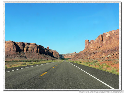
I drove first east bound on I-70 and then south bound on US-191. This part of the country is also sparsely populated, and the scenery along the way pretty much resembles what I saw in western films. These pictures probably will make you feel the same way.

Taking the road between tall standing rocks...

...into wilderness with desert-like plantation...
...with an old train stopped by the road....
...This is just like in the western movies.

When I reached the gate for the Island in the Sky district, something weird came up. My National Park pass was not there in my wallet. I had no idea where else it could be. It just evaporated. So the cost of entrance fee to national parks would add up to my travel bill from this point on.

SmallWorld in front of the huge Mesa Arch

The most popular point to see in this district is the Mesa Arch. This is a point where a stone arch sets in front of a cliff and you can peer through the arch to see the canyon below. It is also a point where thousands of pictures have been taken. And of course, I had to add a few to the photo bibliography to show that I was there.

The trail leading to the Mesa Arch is a short but difficult one. It is difficult not for walking, but for recognizing where the trail is. The whole park is mostly a barren land to me, and it looks extremely similar in every direction. To preserve its original scene, the trails are not paved nor marked with signs and arrows. Instead, they use rock piles to mark the trail, and one should follow the path from one pile of rocks to another. These rock piles blend into the surrounding very well, and it is easy to ignore them and get lost. But it was interesting following these signs to me.
These rock piles (There are two in this picture) are the only signs available for the trail. It is easy to lose them in the world of a single color, and therefore lose the direction.

At the Mesa Arch there were three groups of visitors. They were helping each other taking pictures when I arrived. Seeing no one coming after me, I had no option but asked one gentleman to take pictures for me. He had been busy taking pictures for others before me, as everyone asked him for the same favor. He became a bit annoyed but still helped me out. Here are the pictures at the Mesa Arch.

Mesa Arch from the distance

...Coming close and peering through below the arch...

...and seeing a huge valley down below...

A slightly different view

Me at the Mesa Arch


After he helped me out with the pictures we started a conversation. Interestingly he was also from LA. So I told him about my trip and the transfer from USC to UF. When I finished, he looked at me with a guess-who-you-are-talking-to look on the face, and reached into his pocket for the wallet. Seconds later he showed me an old ID saying "USC faculty". Yes he is a professor at my old school. This was the first time I saw a faculty ID. What a small world this is!

The Grand View Point

After visiting the famous Mesa Arch I continued on to the south most point in the Island in the Sky district, and there is the Grand View Point. The whole Island in the Sky district is a high rising plateau overlooking the rest of the Canyonlands, and the Grand View Point provides one of the most magnificent view. I had to take four pictures and put them together to show you the whole picture. As you may notice from the picture, the rim of the valley down there is white, and hence the primitive road next to the rim was named "White Rim Road". It is possible to descend from the Island in the Sky down to the valley and drive on those roads if one has a four-wheel-drive car. It sounded like a great adventure to me. The roads down there looked distant and lonely, just like another world from atop the island. I did see one or two cars one those roads. However, I couldn't attempt this drive with my Whity.

The panorama at the Grand View Point

Zoom in to the big hole in the valley. It would be a great adventure to go down there.

I walked along the trail from the Grand View Point a little bit to get different views into the valley. The sun was brutally hot by noon time, and I had to retreat to my car after just a short walk.

In the afternoon I checked out several other view points. However, it was too hot that I decided to finish the day at Canyonlands earlier and moved on to Moab, where I planned to spend the night. A few more shots here:
Another view into the canyon.

Yet another view.

The narrow neck of the Island in the Sky district.

Illustration of the "Island in the Sky". It is a plateau connected to the outside world only by the very thin "neck". If the neck is broken, the great views here will be no longer accessible.


Upheaval Dome features a big hole on top of the dome. It is a place to observe all the tilted and displaced rock layers.

Saturday, January 13, 2007

If you prefer pictures

If you prefer to look at pictures rather than words, here is a link to all of the photos I have taken on the trip:

Weijen's photo book

But I was not selective when I uploaded the photos. All the pictures, taken properly or not, are in the photo book. There are around 800 photos with not a single line telling you what's happening. I am a casual photo-taker so most of the pictures are just so-so, nothing more than showing you what I saw. It is up to you if you want to dig something out of it.

When I check back at my own notes about what I should put in the blog, I see "A question about photos" listed. I remeber I had something in mind to ask about the pictures I have taken, but cannot recall what the question is. I want to learn to be a more serious photographer, so if you have anything to comment on my photos, please do let me know. I will appreciate that.

Friday, January 05, 2007

My car Whity and General condition of driving

I think I should spend some time to introduce the pal I travelled with - my car. It served me nicely throughout the trip, and contributed a lot to the pleasent and smooth moving trip. I named it Whity (or "little white") during the trip, for an obvious reason. It is a 97 Toyota Corolla.

I first met Whity at a second-hand car dealer (Topline automobile) one week after I entered US. That time, I decided to stay at an apartment not in USC area, so a car became necessary. I visited the dealer with my mother and Mr. Ho, my father's local friend. Back then I had to decide between two Toyota Corolla's, Whity and Blacky. The black one was older but had less mileage. However my father's friend told me white cars are cooler during hot summer days in South California, so I ended up with Whity.

Since then Whity has been a reliable performer. Corolla is not a car I would go with for a race, but it is (at least mine is) reliable. Within these years, I never had a mechanical problem with the car. I almost forgot that cars, like anything else, is subject to mal-function and breakdown. When I started to plan for the cross-country driving trip, I had little doubt that the car should be able to make it. I had more doubt on myself rather than on Whity.

Of course it was a hard work for Whity. In addition to the 3,000 total miles driven, the car was fully loaded with my belongings for these days (photos here). But it never failed me on the road - the worst incidance being a flat tire, not an internal mechanical problem. I really, really appreciated that. Whity had done his best to make the nice trip possible.

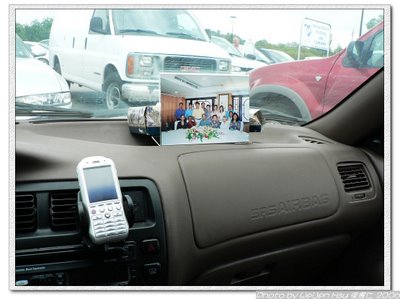
The scene in the car

I took several shots in the car to show you my system. Just like truck drivers who spend a lot of time on the road, I learned to build a system in the car - about where I put the things and how I access them. It started clueless, messy, and unorganized. But through time I improved. I had spent such a long time at the driver's seat during such a short time period that I gained enough experience to make myself a better in-car space organizer and driver.

By the beginning of the trip the space next to the driver was typically a mess. Sure I got everything I need but they were piled on top of each other. You won't like it. I didn't like it myself.

It became much better towards the end of the trip. I must say that I didn't try to make it cleaner for this picture. The camera bag was there for quick access. The bag next to it contained all the travel information I need - The maps, and my own notes for quick reference.

Those two bottles of water were my own timing system. On normal rate, I consumed one bottle of water per hour. When both bottles were empty I knew it was time to stop the car and take a break, visit the restroom. More water were stored down on the floor. The backpack down there contained my laptop computer in case I needed to look something up - it turned out to be the lifesaver on the flat tire incident.
My cellphone was on its holder fixed to the A/C outlet. It was my little communication center for half a month. I had to report to home base everyday so people didn't get over-worried. The picture of my families sit nicely against the windshield.

How difficult was the drive?


When I told people about my driving trip, they worried more about my ability of driving savely to reach the destination than my ability to arrnage the trip so I can have fun. The atmosphere made me a bit upset. True, I am not a professional driver, but I considered myself capable and thoroughly trained in driving. It was partly due to my origin - If LA traffic is notoriously bad, then the traffic in my home town, Taipei City, is simply chaotic. I had been driving in these two places for 10 years combined, so I considered myself experienced in face of various situations on the road.

When I told people I drove from coast to coast, the typical response was like, "That must be tough. Good job." Well in fact it was not that hard. Besides in the major cities, the roads I traveled were not at all busy. I could even recommend this as a beginner's driving drill for most part of the trip - It was an open road, nothing was there for you to hit the break for a good part of the trip. The most dangerous factor was not the other cars on the road, but the sleepiness in my own brain when the driving became a monodic routine for hours. Driving across the country is, after all, very easy as compared to driving in the cities.

Of course there was difference. The most noticeable one was the traffic mix I faced. In cities typically there are more sedan cars on the road than anything else, but on the interstates more than 50% of the cars are big trucks. This sounds intimidating, but in fact trucks post much less danger than other cars to you for good reasons: (1) Most of the trucks are driven by professional drivers. This means they know how to drive, and they know the road and traffic conditions well. (2) The drivers make their living with driving, so they are unlikely to mis-behave on the road and get the license revoked. More than 99.9% of the trucks I met on the trip behave nicely on the road. and (3) Usually the trucks are checked for potential mechanical problems regularly. I saw a lot of cars broken down on the road side along the trip, but never saw one truck sitting there. Consider all these facts, what one should worry more about when driving is really not those huge trucks, but small vehicles with crazy or incapable drivers.

What is more challenging is finding the way. It was relatively easy between cities, and all I did was following the freeways. But in the major cities the freeways form complex interchange and that posted the most challenge to me. LA boasts the most complex freeway system in the country, and a friend once told me if you get along in LA you will be able to get along in any other city in terms of fighting the traffic. But in my personal experience, many other cities, especially when they are on the cross-road where freeways merge, have a fairly complex system at least to first time visitors. Among the cities I traveled, Kansas City, St. Louis, Nashville, and Atlanta stand out in terms of highway system complexity. Luckily, I never got lost during these days, and that was certainly a major part of a happy travel experience.

It is interesting that although I like cool technologies which make life easier, I never considered using a GPS system for this trip. When it comes to the trip planning, I preferred the old-school way - maps. I developed the habit to review the route I would take tomorrow in details before going to bed each day, and put down some quick notes for reference on a small notepad. This, to me, is by far more interesting then relying on a small talking box to show me the way.

My nevigation system. AAA regional maps, AAA state series, and AAA city series. The notepad is the cache.

More about long-distance driving and the suggestions I made after gaining hands-on experience myself on a separate article.